Storm Team4 Forecast: Summerlike heat peaks before rain and cool weather return
4 things to know about the weather:
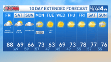
- Temps running 10-15 degrees above average today
- Increasing clouds and rain chances today
- Big cool down this weekend with a wet Sunday
- Could have our first frost/freeze next week
The end of this week comes with good news and bad news if you love warm weather.
The good news is today will be nice and toasty: The D.C. area is making a run at 90° today, with highs at lunchtime well into the 80s. Odds are better for areas south of D.C. along the I-95 corridor.
The bad news? This is going to the last of it for at least the next 10-14 days.
A cold front lurking to the north and west will eventually push through our region during the overnight. As it advances closer to our region throughout the day, clouds will increase along with rain chances.
Expect scattered showers to push into our western suburbs after 2 – 3 p.m. Friday. By the evening, scattered showers will spill east of the mountains, continuing across our region into the overnight and Saturday morning.
Download the NBC Washington app on iOS and Android to check the weather radar on the go.
The front will push south towards the Carolinas on Saturday morning. Rain chances will decrease from the north to the south through the morning, which means areas from D.C. and to the north will likely be dry Saturday with sunshine. More clouds and rain chances linger for locations closer to Central Virginia.
Daytime high temperatures this weekend fall into the 60s. By Sunday, an area of low pressure will ride along with a stalled front bringing a cold soaking rain to the region.
All of the rain last week, combined with more showers this weekend, is thankfully chipping away at the drought in our region.
We dry out on Monday with breezy northwest winds and low humidity. Sunshine returns with temps back in the lower 70s. Chilly mornings are upon us for next Tuesday and Wednesday. We could have some overnight lows dip into the 30s, so we will have to watch for some frost and freeze advisories/warnings.
WRC
WRC
QuickCast
TODAY:
Hot
Increasing clouds
PM scattered showers
Temps: Mid to upper 80s
Wind: SW 5-10 mph
TONIGHT:
Scattered showers
Falling temps
Temps: Upper 60s and falling
Winds: N 5-10 mph
SATURDAY:
Drying from the north to the south through the early AM,
Scattered showers southern suburbs
Temps: 60s
Winds: N 5-10mph
SUNDAY:
Showers and cool
Temps: Mid 60s
Winds: NE @ 5 MPH
MONDAY:
Sunny and breezy
Temps: Lower 70s
Winds: NW 10-20+