Storm Team4 Forecast: Rainy days are over but DC area stays cool and breezy
4 things to know about the weather:
- Dry weather returns
- Breezy pattern remains
- Small weekend rain chance
- Back near 80° next week
Our multi-day rain event is over.
Rain totals over the last three to four days were mostly in the 1.5 to 2.5 inches range with isolated spots getting just over 3 inches. DCA had 1.64 inches, IAD had 1.98 inches and BWI had 1.68 inches.
Now that the rain is over, let’s see about getting some sunshine back in the forecast. Clouds will remain quite thick for most of Thursday but there will be some brightening to the sky Thursday afternoon and there should be enough sun to cast a shadow.
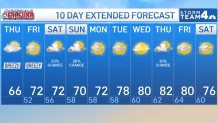
A somewhat gusty northeast wind will be with us all day and that will keep afternoon highs in the mid-60s.
Speaking of the wind, areas along the western shore of the Bay, the tidal Potomac and especially the Eastern Shore beaches, will have high water issues for the next few days.
The Oceans Calling Festival concerns in Ocean City will have very impactful weather conditions: spits of rain, very high tides and winds gusting over 40 mph. Far worse than the weather, we’ll end up with on this side of the Bay.
Download the NBC Washington app on iOS and Android to check the weather radar on the go.
Warming up a little for the weekend
In our area, wind will turn to the north Friday northwest for the weekend but remain in the 20 mph each afternoon.
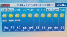
Most of the DMV will get back to 70° on Friday and near 75° on Saturday. Friday afternoon will be the sunniest day of the week.
A powerhouse of a storm of the New York/New Jersey coast will send increasing clouds our way on Saturday afternoon and could deliver a quick shower or two for areas east of I-95.
Thicker cloud cover will return for Sunday and Monday but the air at the surface will be dry enough to keep rain chances out of the forecast. Highs on Sunday and Monday will only be around 70°.
The return of southerly winds will finally put us back in the 75-80° from Tuesday onwards so next week will be the complete opposite of this one.
NBC Washington
NBC Washington
QuickCast
THURSDAY:
Breezy and cool
Mostly cloudy morning
Some afternoon clearing
Wind: northeast 12-22 mph
Chance of rain: 0%
HIGHS: 62° to 68°
THURSDAY NIGHT:
Decreasing clouds
Steady breeze
Coolest along I-81 corridor
Wind: northeast 6-12 mph
Chance of rain: 0%
LOWS: 45° to 55°
FRIDAY:
Partly to mostly sunny
Breezy
Milder
Wind: north 15-25 mph
Chance of rain: 0%
HIGHS: 68° to 73°
SATURDAY:
Sunny morning
Afternoon clouds
Shower possible near the Bay
Wind: northwest 15-30 mph
Chance of rain: <20%
HIGHS: 70° to 75°
SUNDAY:
Increasing clouds
Blustery and cool
1 or 2 showers possible
Wind: northwest 15-25 mph
Chance of rain: 25%
HIGHS: 65° to 70°
Sunrise: 6:58 Sunset: 7:02
Average High: 78° Average Low: 61°