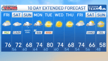
Storm Team4 Forecast: Nice, warm Friday before Isaias brings weekend rain
4 things to know about the weather:
- Sunny stretch is over
- Staying dry for now
- Prepare for heavy rain
- Likely 1-2 inches on Sunday
Hurricane Isaias will make a landfall on the Gulf Coast Friday evening with sustained winds near 110 mph.
The eye of the storm is expected to cross the coastline near Pensacola, Florida, around sunset. After landfall, the storm will break into two main parts. The parent circulation will move northwestwards heading into west-central Tennessee by Saturday night.
The main slug of deep, tropical moisture will move northeast into Georgia and the Carolinas. This means that widespread travel disruptions will be an issue from the Gulf Coast to Birmingham, Memphis, Nashville and Atlanta for Friday and Saturday.
On Saturday night, that area of heavy rain will advance into the southern Appalachians and south-central Virginia. By Sunday morning rain will be reaching our area.
Take full advantage of Friday and Saturday’s dry weather to insure that you and your property are prepared for heavy rain that will last all day on Sunday. Clean out the storm drains and gutters and secure all loose outdoor items.
Download the NBC Washington app on iOS and Android to check the weather radar on the go.
How much rain will the DC area get?
The winds in our area will be in the 20-30 mph range but with a driving rain, you most certainly will not want to be outside.
The main update to the forecast is that the heavier rain now looks more likely to get here earlier in the day on Sunday. This is not good news for those going to the Commanders game Sunday afternoon or any other outdoor activities.
Rain totals for this storm starting 5 a.m. Sunday to 11 a.m. Monday are expected to be in the 1.5 to 2 inch range with local amounts possibly as much as 2.5 to 3 inches . That much rain in a 24-30 hour period could certainly cause some flooding concerns so it would be be to stay safe, dry and at home if possible.
The rain will end Monday morning and there’s likely to be some sunshine by Monday afternoon. In the wake of the storm Tuesday should be sunny, warm and humid with highs in the upper 70s and low 80s. A cold front Tuesday night will bring cooler, more October-like conditions back for the second half of next week.
NBC Washington
NBC Washington
QuickCast
FRIDAY:
Increasing clouds
A bit cooler
Very low humidity
Wind: northwest 5-10 mph
Chance of rain: 0%
HIGHS: 70° to 75°
FRIDAY NIGHT:
Mostly cloudy
Cool and dry
Some areas of fog
Wind: north <5 mph
Chance of rain: 0%
LOWS: 53° to 58°
SATURDAY:
Mostly cloudy
Dry through sunset
Late evening showers possible
Wind: east/southeast 10 mph
Chance of rain: 20%
HIGHS: 67° to 72°
SUNDAY:
Cloudy , breezy and wet
Steady rain by 9AM
Periods of heavy rain likely
Rain totals 1.5”-2”
Wind: east 15-25 mph
Chance of rain: 100%
HIGHS: 63° to 68°
MONDAY:
Clouds, rain early
Afternoon clearing
Mild and breezy
Wind: northwest 15-25 mph
Chance of rain: 80%
HIGHS: 70° to 75°
Sunrise: 7:12 Sunset: 6:38
Average High: 72° Average Low: 55°