Storm Team4 Forecast: Getting warmer in the 70s before hotter temps arrive
4 things to know about the weather:
- Dry weather returns
- Sunny days start Wednesday
- Nearing 90° by Friday
- Sunday soaking looks likely
High pressure over the Great Lakes will finally shove the weekend nor’easter out to sea. As the storm and its attending cloud deck move out, our weather will improve.
Sunshine will still be at a premium Tuesday but there will be enough breaks in the clouds Tuesday afternoon to at least see your shadow from time to time.
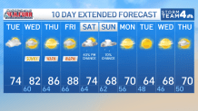
Highs Tuesday afternoon will be just at, or slightly below, our average of 76°. Drier air will help to clear our skies after sunset allowing temperatures to fall into the 50s outside the Beltway (60s inside) by Wednesday morning.
Wednesday, Thursday and Friday will all be filled with sunshine as temperatures climb well above average. Highs will be around 80° on Wednesday, 85° on Thursday and very close to 90° on Friday.
If Reagan National Airport can reach 90° on Friday, it will be only the 11th time in the last 40 years to reach 90° in October. Working in favor of reaching 90° will be southwest winds and enough humidity to keep sunrise temperatures near 70°.
Download the NBC Washington app on iOS and Android to check the weather radar on the go.
Rain chances for this weekend
Working against will be increasing clouds and a small, less than 20% chance of some late day showers. Either way Friday will still be about 15° above average.
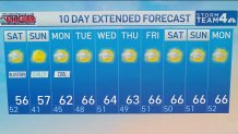
A cold front will reach the area on Saturday so weekend highs will struggle to reach 70°. Most of the area will be dry to start but rain chances will increase steadily into Saturday afternoon and evening. Periods of steady rain, perhaps even heavy at times, look like for Saturday night and Sunday.
Dry weather will return early next week as true, October weather takes hold. The first chance for frost may come to the Shenandoah Valley, northern Maryland and the West Virginia mountains next Tuesday morning.
QuickCast
TUESDAY:
Mostly cloudy morning
Some afternoon clearing
A bit milder
Wind: northwest 4-8 mph
Chance of rain: 0%
HIGHS: 70° to 75°
TUESDAY NIGHT:
Evening cloudiness
Overnight clearing
Seasonably cool
Wind: variable 5 mph
Chance of rain: 0%
LOWS: 56° to 62°
WEDNESDAY:
Mostly sunny
Nice and warm
A bit humid
Wind: southwest 4-8 mph
Chance of rain: 0%
HIGHS: 78° to 83°
THURSDAY:
Mostly sunny
Nice and warm
More humid
Wind: southwest 5-10 mph
Chance of rain: 0%
HIGHS: 83° to 88°
FRIDAY:
Mild, sunny morning
Increasing afternoon clouds
Humid for October
Wind: southwest 5-10 mph
Chance of rain: 10%
HIGHS: 85° to 90°
Sunrise: 7:02 Sunset: 6:54
Average High: 76° Average Low: 59°