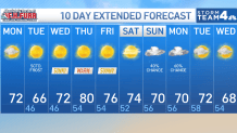
Storm Team4 Forecast: Foggy, chilly morning warms up into low 70s on Monday
4 things to know about the weather:
- Cloudy, foggy start
- Here comes the sun
- Frost in the mountains
- Next rain 7-8 days away
After a very active and generally cloudy, rainy pattern these past two weeks, we’ve certainly earned a week of quiet, fall weather.
This new week will begin with areas of very dense fog that might well take most of the morning to finally dissipate. Once it does, our skies will turn sparkling blue Monday afternoon, and each afternoon all week.
The way things look now, our next chance for rain isn’t expected until maybe Sunday or, more likely, next Monday. This will be a nice chance for everything to finally dry out again.
Since we’re starting in the 50s to near 60s Monday morning, most of the D.C. metro area will reach the low 70s Monday afternoon. Steady northwest winds will push very dry air into the region so get ready for some very chilly mornings.
Chilly nights and mornings
I mentioned a week ago that frost would be a possibility Monday night and Tuesday night and I stand by that forecast.
Frost advisories have already been issued for far western Maryland and the Allegheny mountains or West Virginia for Monday night. Those advisories could be expanded to include parts of eastern West Virginia, northern Maryland and the Shenandoah Valley for either Monday night or, more likely, Tuesday night.
Lows in downtown D.C. and adjacent to the Bay will likely stay in the upper 40s while the cooler suburbs north and west of the Beltway will be closer to 40°. Grab the extra blanket and a warmer coat for these next few nights and early mornings.
Download the NBC Washington app on iOS and Android to check the weather radar on the go.
Tuesday afternoon will be the coolest of the week, with highs only reaching the low to mid-60s. After another cold start Wednesday morning, our winds will turn back to the southwest by Wednesday afternoon bringing low to mid-70s our way.
Thursday looks sunny and warm with highs close to 80°. Friday and Saturday look dry and delightful with highs mostly in the mid-70s.
QuickCast
MONDAY:
Thick fog this morning
Sunny by noon
Mild, breezy afternoon
Wind: northwest 12-22 mph
Chance of rain: 0%
HIGHS: 68° to 73°
MONDAY NIGHT:
Clear, very chilly
Coldest along, west of I-81
Mildest in city centers, near Bay
Wind: northwest 5-10 mph
Chance of rain: 0%
LOWS: 38° to 50°
TUESDAY:
Sunny skies
Crisp and cool
Light breeze
Wind: North/west 5 mph
Chance of rain: 0%
HIGHS: 60° to 65°
WEDNESDAY:
Another chilly start
100% pure sunshine
Seasonably mild
Wind: southwest 5-15 mph
Chance of rain: 0%
HIGHS: 70° to 75°
THURSDAY:
Mostly sunny
Nice and warm
Very low humidity
Wind: west 5-10 mph
Chance of rain: 0%
HIGHS: 77° to 83°
Sunrise: 7:08 Sunset: 6:44
Average High: 74° Average Low: 57°