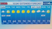
Storm Team4 Forecast: Clouds and showers to end the weekend
4 things to know about the weather:
- Clouds and showers to end the weekend
- Sunshine makes a comeback Monday
- Fall air arrives
- Best day for outdoor plans: Tuesday
Sunday will be the grayest day of the stretch with periods of light rain and showers, especially during the morning and midday hours.
The storm system pulls away Monday, allowing skies to gradually brighten and drier air to move into the region.
Download the NBC Washington app on iOS and Android to check the weather radar on the go.
A refreshing northwest breeze brings lower humidity and cooler temperatures Monday into Tuesday, making it feel much more like October.
Tuesday looks fantastic with plenty of sunshine, comfortable temperatures and dry weather from start to finish.
QuickCast
SUNDAY
Cloudy, cool and occasionally wet
Cloudy skies
Periods of light rain and scattered showers
Damp conditions through much of the day
Limited sunshine, if any
Cool for early October
Wind: NE 5 to 10 mph
High Temperature: 64°-67°
SUNDAY NIGHT
Mostly cloudy skies
Areas of patchy fog possible
A few lingering damp spots early
Quiet overnight conditions
Wind: Light and variable
Low Temperature: 58°-61°
MONDAY
Improving and breezy
Morning clouds giving way to afternoon sunshine
Dry weather returns
Breezy at times
Comfortable fall conditions
Wind: NW 10 to 15 mph, gusts to 20 mph
High Temperature: 71°-73°
MONDAY NIGHT
Mostly clear skies
Cool and refreshing
Low humidity returns
Great sleeping weather
Wind: N 5 to 10 mph
Low Temperature: 47°-50°
TUESDAY
Bright, sunny and comfortable
Plenty of sunshine
Dry weather all day
Crisp fall air
Excellent conditions for outdoor activities
Wind: NW 5 to 10 mph
High Temperature: 65°-67°
TUESDAY NIGHT
Clear skies
Cool and comfortable
Pleasant evening conditions
Wind: Light and variable
Low Temperature: 47°-49°