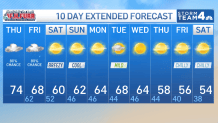
Storm Team4 Forecast: Expect light showers and humidity for Thursday
4 things to know about the weather:
- Rain in spots overnight
- Showers tomorrow morning, chance afternoon shower otherwise clearing
- Blustery weekend
- 60s and mainly dry next week
Today ended our dry spell with some morning showers. Prior to today, we had 18 consecutive days without rain.
Some moderate to heavy rain moves in late tonight into very early tomorrow morning.
By the morning commute, expect scattered showers with the steadiest rain east of the Bay.
The afternoon is looking dry. However, there is a small chance another area of showers moves through along and east of I-95.
This will lead to a wide range in rainfall totals with some seeing barely any while areas south and east could see over 2”.
The weekend it will be dry, chilly and breezy with highs in the low 60s.
Wind chills Sunday morning will be in the 30s.
Download the NBC Washington app on iOS and Android to check the weather radar on the go.
Friday’s rain chances
The wildcard for rainfall will come Friday afternoon and evening as the cold front tries to finally shove this high humidity air out to sea.
There is good agreement among the forecast models that a stripe of 1 inch to 2 inches or more rain totals is likely for Southern Maryland, the Northern Neck, the lower bay and much of the eastern shore. Ocean City, Maryland, and Rehoboth Beach, Delaware could get over 2 inches.
Frequent showers Friday will keep temperatures in the mid-to-upper 60s most of the day. A secondary cold front will arrive late Friday night and bring much more November-like conditions along with it.
All this will come to an end Friday night and the weekend looks dry from the Blue Ridge to the Bay to the beaches. That dry pattern looks to hang around for most of next week too so hopefully you get the rain you need before sunset Friday.
Gusty northwest winds will be with us all day Saturday and for the first half of Sunday. The breeze will push the clouds away so, after a cloudy start, sunshine will return for late Saturday afternoon and Sunday. Temperatures will struggle to reach 60° on Saturday and only get just above 60° on Sunday. Overnight lows will be returning to the chilly 40s.
QuickCast
TONIGHT:
Showers/rain at times, some heavy rain in spots.
Cloudy and mild otherwise
Low: 62°
FRIDAY:
AM showers, chance PM rain otherwise clearing
High: 69°
SATURDAY:
Partly to mostly sunny, breezy and much cooler
High: 60°
SUNDAY:
Sunny, breezy and seasonably cool
High: 62°
Monday:
Sunny and nice
High: 63°
Sunrise: 6:40 Sunset: 5:03
Average High: 62° Average Low: 45°