A joint Cumming death investigation is currently underway after authorities discovered an unidentified deceased individual on Friday afternoon, March 13, 2026. Officers located the body hidden inside a grassy area off Bald Ridge Road near Pirkle Ferry Road in Cumming, Georgia. Consequently, the Georgia Bureau of Investigation and the local police department immediately launched an active inquiry. Search teams found the remains directly behind a busy gas station and a local shopping center. As a special detail, the GBI deployed an advanced aerial drone over the nearby woods to assist ground investigators. Ultimately, police officers secured the grim scene, safely recovered the body, and officially confirmed no ongoing public danger exists. First responders and crime scene technicians continue processing the commercial perimeter carefully. The sudden discovery deeply shocked local residents navigating the busy afternoon traffic corridor. Law enforcement leadership currently promises a highly transparent and incredibly thorough regional investigation.
Initial Discovery Near Pirkle Ferry Road
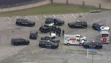
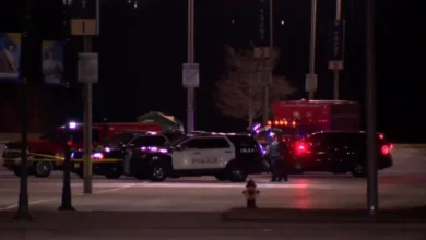
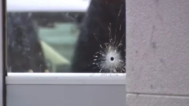
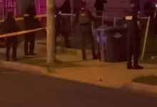
The unsettling incident began unfolding rapidly during the busy Friday afternoon commute. Local news footage captured numerous marked police vehicles swarming the commercial district quickly. Emergency dispatchers directed multiple patrol units toward the specific grassy patch near Pirkle Ferry Road. Upon their rapid arrival, first responders immediately taped off the heavily wooded perimeter. Crime scene technicians subsequently wheeled a medical gurney toward the hidden brush area. Shoppers at the nearby retail center watched the massive police presence with growing concern. Therefore, law enforcement officers worked diligently to shield the recovery efforts from public view. Maintaining a secure and uncontaminated crime scene remains absolutely critical for accurate forensic analysis. Detectives meticulously searched the surrounding foliage for any potential physical evidence. Furthermore, officers canvassed the adjacent gas station searching for vital security camera footage. Finding clear video evidence could drastically accelerate the timeline of this complex investigation. Uniformed patrol units directed heavy local traffic away from the immediate commercial zone.
Aerial Drones and GBI Investigative Protocols
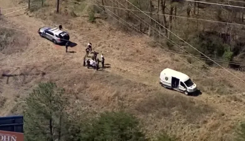
The local police department quickly requested specialized assistance from state-level authorities. Consequently, the Georgia Bureau of Investigation deployed highly trained forensic agents to the scene. These experienced state investigators provide crucial technological resources during complex local inquiries. Specifically, the GBI utilized a high-resolution aerial drone to survey the dense surrounding woods. This advanced aerial mapping technology helps detectives identify hidden pathways or scattered evidence from above. State protocols dictate that the GBI medical examiner will conduct a thorough autopsy soon. Medical professionals must scientifically determine the exact cause and precise manner of death. Forensic pathologists will analyze tissue samples and review toxicology reports extensively. Identifying the deceased individual remains the absolute highest priority for the investigative team currently. Resolving these sudden death cases requires immense patience and extreme scientific precision. The state crime lab utilizes cutting-edge genetic testing to match missing persons records accurately. Once the medical examiner completes the examination, officials will promptly notify the victim’s next of kin. This formal notification process ensures grieving families receive the tragic news respectfully and privately.
Cumming Demographics and Regional Safety Context
This sudden Cumming death investigation deeply unsettled the typically peaceful Forsyth County community. Cumming sits approximately forty miles north of Atlanta and represents a highly affluent suburban enclave. The city generally maintains exceptionally low violent crime rates compared to national averages. In fact, analytical data reveals that Cumming is significantly safer than seventy-two percent of American cities. The local violent crime rate currently stands at an incredibly low one in 1,454 residents. Consequently, discovering a deceased body behind a bustling commercial center deeply shocks local families. The rapid deployment of state-level investigators underscores the immense seriousness of this unusual event. City administrators continuously monitor these rare public safety anomalies very closely. Maintaining a secure environment remains absolutely essential for supporting the rapidly growing local economy. Forsyth County constantly attracts new residents seeking top-tier schools and quiet suburban neighborhoods. Therefore, local police prioritize rapid incident resolution to protect the overarching municipal reputation.
Reassuring Public Safety and Community Security
Despite the massive police presence, authorities quickly moved to calm anxious local residents. Officials from the Cumming Police Department released a joint public safety statement immediately. The Forsyth County Sheriff’s Office also collaborated to distribute this vital community update. Law enforcement leaders officially confirmed that absolutely no ongoing danger threatens the general public. Detectives firmly believe this tragic incident represents an isolated local event. Therefore, nearby businesses and commercial shopping centers remain completely open for regular operations. Patrol officers simply ask drivers to avoid the specific Bald Ridge Road recovery zone temporarily. This simple traffic diversion allows forensic teams to work safely alongside the busy roadway. Consistent communication from police departments prevents dangerous rumors from spreading across social media platforms. Community trust relies heavily upon transparent and timely official public safety updates. Officers will likely maintain a highly visible presence near the shopping center throughout the entire weekend. This visible deterrence provides immense psychological comfort to nervous local retail employees.
Next Steps in the Active Inquiry
Currently, the joint Cumming death investigation remains in its very early preliminary stages. Detectives withhold specific details regarding the condition of the recovered remains intentionally. Protecting sensitive information prevents false confessions and preserves the integrity of the active inquiry. Investigators desperately need assistance from anyone who visited the nearby gas station recently. Observant witnesses often provide the missing puzzle pieces necessary to solve complex local mysteries. Therefore, authorities strongly encourage citizens to contact the police department with any relevant information. Even seemingly insignificant details could prove absolutely vital for the lead forensic detectives. Read our previous coverage on regional emergency responses, such as when CPS canceled classes during extreme cold, for more important safety context. Residents can monitor official press releases through the Georgia Bureau of Investigation website. You can also review local safety initiatives via the Cumming Police Department. Stay updated with the latest criminal investigations at wfbnews.com.