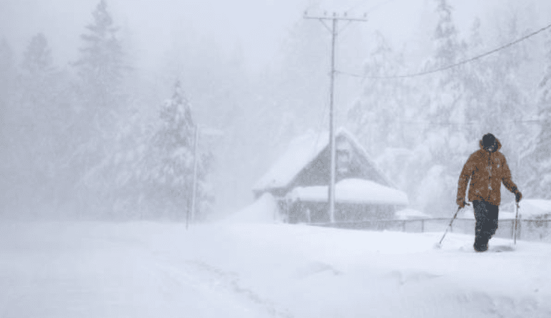
A historic weather event is taking shape this Thursday. Meteorologists warn that a massive 2,000-mile winter storm will sweep across the United States over the next 72 hours. This system threatens more than 35 states with heavy snow, lethal ice, and bone-chilling temperatures. Currently, the National Weather Service (NWS) has placed more than 70 million Americans under winter storm watches. In total, the system will impact over 200 million people from the Southwest to the Northeast.
Path of Destruction: From Texas to the Northeast
The geographic reach of this system is staggering. The storm stretches approximately 2,000 miles diagonally across the continent. It begins its impact in Texas and Oklahoma before moving eastward through the Deep South. From there, it will curve upward into the Mid-Atlantic and New England.
Forecasters expect the precipitation to begin in earnest on Friday, January 23. The storm will intensify rapidly as it clashes with moisture from the Gulf of Mexico. Consequently, the system will broaden its reach throughout the weekend. The peak of the storm will likely hit the heavily populated I-95 corridor from Sunday into Monday.
“This is a classic, high-impact winter event,” stated a lead meteorologist at the NWS. “We rarely see a single system cover this much territory with such intensity.”
Residents in the Carolinas and Virginia face a particularly complex forecast. These regions sit on the transition line between rain, snow, and freezing rain. A shift of just 50 miles could change a heavy snow event into a disastrous ice storm. Therefore, officials urge residents in these transition zones to prepare for the worst-case scenario.
Crippling Ice and Heavy Snow Threats
Precipitation types will vary sharply depending on location. To the north and west of the storm’s center, cold air will support heavy snow. Major metropolitan areas, including Washington D.C. and New York City, are in the crosshairs. Current models suggest these cities could receive a foot or more of snow accumulation.
The Appalachian Mountains will likely see the highest totals. Some higher elevations could record snowfall approaching two feet. This heavy, wet snow poses a risk of collapsing roofs and trapping residents in their homes.
However, the threat to the south is perhaps more dangerous. A band of freezing rain will develop from Northern Texas across to the Mid-Atlantic. Forecasters warn of “crippling” ice accumulation. Some areas may see up to half an inch of ice glaze on all surfaces.
Ice accumulations of this magnitude are catastrophic for infrastructure. A half-inch of ice adds hundreds of pounds of weight to tree limbs and power lines. Consequently, widespread power outages are almost certain. Utility companies warn that restoration efforts could take days if roads remain impassable.
Life-Threatening Arctic Blast Follows
The precipitation is only the first chapter of this weather story. Behind the 2,000-mile winter storm, a brutal Arctic air mass will plunge southward. This polar air will flash-freeze any wet surfaces, turning roads into skating rinks.
Temperatures will drop well below freezing across the affected 35 states. In the Northern Plains and parts of the Midwest, wind chills will plummet to dangerous levels. Some regions expect wind chill values as low as minus 40 degrees.
Exposure to such extreme cold can cause frostbite in minutes. Health officials advise residents to limit time outdoors. Furthermore, the combination of power outages and subzero temperatures creates a life-threatening situation for vulnerable populations.
“If the power goes out, homes will lose heat rapidly,” said a FEMA spokesperson. “This Arctic blast makes the reliability of the power grid a matter of life and death.”
Travel Chaos and Infrastructure Warnings
The transportation sector is already reacting to the forecast. Major airlines, including Delta and United, have issued travel waivers. These waivers cover dozens of airports along the storm’s path. They allow passengers to rebook flights without penalty to avoid the weekend chaos.
Flight cancellations will likely number in the thousands by Friday afternoon. Hubs in Chicago, Newark, and Dallas anticipate significant disruptions. Travelers should check their flight status before heading to the airport.
On the ground, conditions will be equally treacherous. Departments of Transportation across the South and Northeast are pre-treating highways. However, crews warn that they cannot fight ice effectively once it begins to fall.
Texas officials are taking no chances. The state has already declared a state of emergency. This declaration allows the rapid deployment of resources to assist stranded motorists and support the power grid. The memory of past winter grid failures remains fresh in the minds of many Texans.
Safety Preparations and Emergency Declarations
Authorities urge all residents in the path of the 2,000-mile winter storm to finalize preparations by Thursday night. Once the storm begins on Friday, travel will become hazardous.
Emergency management agencies recommend stocking a 72-hour supply of food and water. Families should also have flashlights, batteries, and extra blankets ready. Those who rely on medical devices should have a backup power plan.
“Do not wait until the first flake falls,” advised a Maryland emergency management official. “Grocery store shelves will empty quickly. Get what you need now and plan to stay home.”
Homeowners should also prepare their properties. bringing pets indoors is essential. Insulating outdoor faucets can prevent pipe bursts during the coming freeze. Additionally, clearing gutters can help prevent ice dams from forming on roofs.
Outlook: A Long Weekend Ahead
The impacts of this storm will linger well into next week. Schools across the region are already considering closures for Friday and Monday. The cleanup process will be slow due to the extreme cold that follows the snow.
Road crews will prioritize main arteries. Residential streets may remain unplowed for days in areas with the heaviest accumulation. Patience will be key as the nation weathers this significant winter challenge.
WFBNews will continue to monitor the storm’s track. We will provide real-time updates on snowfall totals and power outages as the system moves across the country.