By Clara Wilson
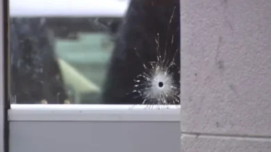
A violent encounter at a Rhode Island ice rink resulted in multiple fatalities on Monday afternoon. Law enforcement officers responded to reports of a Pawtucket arena shooting at the Dennis M. Lynch Arena on February 16, 2026. The incident occurred around 2:30 p.m. during a high school co-op hockey game. Consequently, the local community remains in a state of shock as details of the tragedy emerge. Authorities confirmed that two victims died following the gunfire. This group includes a young girl who perished at the scene and a woman who later died at a hospital. The suspected gunman also died from an apparent self-inflicted gunshot wound.
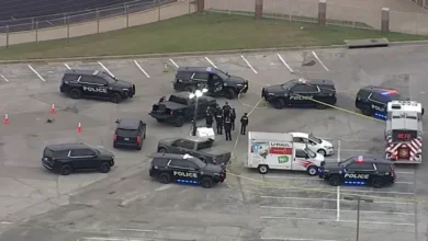
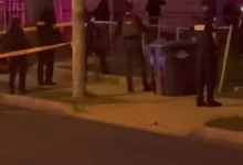
The Pawtucket Police Department worked alongside the Rhode Island State Police to secure the facility. Furthermore, federal agents from the ATF arrived to assist with the immediate investigation. This Pawtucket arena shooting represents a significant escalation of violence in a public recreational space. Hundreds of students and parents were present when the shots rang out during the athletic event. While the physical threat has ended, the emotional trauma for the witnesses is immense. Investigators spent several hours processing the crime scene to reconstruct the sequence of events.
Chaos Erupts at Dennis M. Lynch Arena
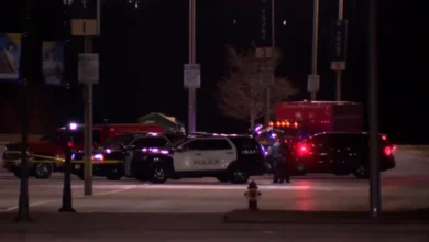
The atmosphere inside the Dennis M. Lynch Arena turned from competitive to chaotic within seconds. Witnesses reported hearing several loud pops during the middle of the hockey game. Many people initially confused the sound with equipment hitting the ice or the boards. However, the screams of bystanders quickly alerted the crowd to the actual danger. People scrambled for exits while others sought cover behind the bleachers. The local police department arrived within minutes of the first 911 calls. They immediately established a perimeter to prevent the shooter from escaping the building.
Medical personnel found a young girl with critical injuries near the seating area. Despite their best efforts, she did not survive the encounter. Paramedics also treated a woman who sustained life-threatening wounds. They rushed her to a nearby trauma center where she eventually succumbed to her injuries. In addition to the fatalities, three or four other individuals required hospitalization for various gunshot wounds. Doctors currently describe their conditions as stable but serious. The medical examiner’s office is currently working to confirm the identities of all victims involved in the Pawtucket arena shooting.
Domestic Motive in the Pawtucket Arena Shooting
Preliminary findings from the Rhode Island State Police suggest a specific motive for the violence. Law enforcement officials believe the incident was domestic in nature. The gunman reportedly targeted members of his own family who were attending the game. This focused attack explains why the shooter moved toward a specific section of the bleachers. The suspect did not appear to be firing at the general public randomly. Instead, he sought out individuals with whom he had a prior relationship. This development has shifted the focus of the criminal investigation toward the suspect’s domestic history.
The gunman took his own life shortly after the initial attack ended. Officers found him with a self-inflicted gunshot wound in a different part of the arena. This conclusion to the violence prevented a prolonged standoff with law enforcement. However, it also leaves many questions regarding the shooter’s specific frustrations. Detectives are currently reviewing his digital communications and social media profiles. They want to know if he made any threats leading up to the Monday afternoon game. Understanding the history of the domestic dispute is vital for the final police report.
Community and School Response to the Crisis
The sheer scale of the emergency required a multi-jurisdictional response. Units from Pawtucket, Providence, and the State Police converged on the arena. ATF agents joined the scene to assist with the ballistics and firearm tracing. These specialists are investigating how the suspect obtained the weapon used in the Pawtucket arena shooting. They are also looking into whether the firearm was legally registered. Such a heavy law enforcement presence is rare for a municipal athletic facility. The intensity of the response highlights the severity of the threat to the public.
Furthermore, several local schools had teams participating in the co-op hockey game. These included students from Coventry, Johnston, and St. Raphael Academy. Students from Providence Country Day, North Providence, and North Smithfield were also present. School administrators worked quickly to account for every student and staff member. Fortunately, all participating students were reported safe following the evacuation. The schools have provided counselors to support the athletes who witnessed the violence. This traumatic event will likely impact the remainder of the local high school sports season.
Local Perspective: Vulnerability of Community Centers
The state of Rhode Island is currently grappling with a rise in high-profile violent incidents. Based on local crime data from the last twelve months, this Pawtucket arena shooting follows a troubling pattern. Specifically, this tragedy occurred only two months after a fatal shooting at Brown University in Providence. These events suggest that traditional “safe zones” are increasingly vulnerable to external threats. The Pawtucket community must now reconsider the security protocols for amateur and youth sporting events.
Consequently, many parents are calling for metal detectors and a permanent police presence at local rinks and gymnasiums. In a state with a tight-knit athletic community, the sense of security has been fundamentally broken. The transition from open-access public arenas to high-security zones represents a significant cultural shift for Rhode Island residents. Furthermore, the trauma experienced by the student-athletes from six different schools will require long-term mental health intervention. This incident forces a difficult conversation about the intersection of domestic disputes and public safety.
Editorial Analysis: The Impact of Public Domestic Violence
The intrusion of domestic violence into a public sporting event highlights a failure in modern preventative measures. In 2026, we see a trend where domestic disputes are no longer confined to private residences. These conflicts now frequently spill into community hubs like the Dennis M. Lynch Arena. This shift forces a “hardening” of previously soft targets, which ultimately erodes the communal trust necessary for local athletics. If we cannot protect families in a community rink, the psychological cost to the next generation of athletes will be immeasurable.
Governor Dan McKee issued a formal statement shortly after the situation was contained. He described the shooting as a “tragic” and “isolated” incident that has shaken the state. He emphasized that his office is monitoring the investigation closely. Pawtucket Mayor Donald Grebien also spoke to the media outside the arena. He praised the rapid response of the first responders and offered his condolences to the families. Both leaders stressed that the public should feel safe as the shooter is no longer a threat. However, their words do little to ease the grief of those who lost loved ones.
Stay updated with the [latest criminal investigations] at wfbnews.com.