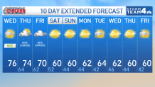
Storm Team4 Forecast: Dry, warm day ahead of rain chances closing out workweek
4 things to know about the weather:
- Last warm, dry day
- Showers Thursday
- Rain could be heavy Friday
- Cool, dry weekend
Our long run of beautiful, dry, fall weather is coming to an end after Wednesday.
It’s been 18 days since our last rainfall but rain remains in the forecast for Thursday and Friday. That means you should take advantage of Wednesday’s mid-70s and sunshine as best you can.
Clouds will begin arriving Wednesday afternoon but our first raindrops are not expected until around daybreak Thursday. With a surge of very warm and very humid air coming ahead of a cold front, the next 24 to 48 hours will feel much more like early September than early November.
Temperatures will remain in the low 60s Wednesday night which is nearly 20° milder than average. That mild start means that most areas will still be able to reach the low to mid-70s on Thursday even without any sunshine and the occasional rain shower. Rain totals Thursday will be around a quarter of an inch.
Download the NBC Washington app on iOS and Android to check the weather radar on the go.
The big question is how much rain will we get on Friday. A cold front will interact with the incredibly humid air-mass to wring out some very impressive rain totals. The issue is exactly where that heavy rain will fall.
Most of our forecast models put the stripe of heavy rain just east of the I-95 corridor over the Bay and the Delmarva Peninsula. The Maryland and Delaware shore are likely to get nearly 2 inches of rain while most of the DC metro will likely get half an inch to 1 inch.
West of I-95 to the Blue Ridge will get lower totals and the I-81 corridor may not get much rain at all on Friday.
Temperatures cool off into next week
Temperatures will briefly get near 70 on Friday° before the cold front and the rain finally take hold. The good news is that the weekend should be dry for most of the region. Daytime highs will be in the 50s to low 60s both days with Sunday being the sunnier half of the weekend.
Most of next week looks seasonably cool and dry with highs near 60° and lows around 40°. Starting with this weekend, it might be a long, long time before we see 70° again. Last year, D.C. only reach 70° twice between Nov. 4 and the beginning of March: once on Nov. 5 and again on Nov. 26.
Thanks to El Niño, our odds of seeing a few 70s this winter are better than average. The last strong El Niño delivered us three days in the 70s in December of 2015.
NBC Washington
NBC Washington
QuickCast
WEDNESDAY:
Sunny through noontime
Cloudy by evening
Nice and warm
Wind: south/southeast 10 mph
Chance of rain: 0%
HIGHS: 72° to 77°
WEDNESDAY NIGHT:
Mostly cloudy
Very mild for November
Showers by morning
Wind: south 5-15 mph
Chance of rain: 60%
LOWS: 58° to 64°
THURSDAY:
Cloudy, mild & humid
Periods of light rain likely
Rainfall less than 1/4”
Wind: southwest 10-20 mph
Chance of rain: 80%
HIGHS: 70° to 76°
FRIDAY:
Cloudy, mild and humid
Rain likely much of the day
Locally heavy rain possible
Wind: north 5-10 mph
Chance of rain: 80%
HIGHS: 65° to 70°
SATURDAY:
Partly cloudy
Breezy and cooler
Much lower humidity
Wind: northwest 12-24 mph
Chance of rain: 20%
HIGHS: 58° to 64°
Sunrise: 6:39 Sunset: 5:04
Average High: 62° Average Low: 45°