WEATHER ALERT: Chilly Sunday with rain, possible flooding
4 things to know about the weather:
- Rainy, chilly and blustery Sunday
- Tracking flooding and isolated tornado risk
- Mild Tuesday and Wednesday
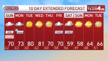
- Chilly next weekend
A wind advisory is in effect for the Blue Ridge until 11 a.m. Sunday with a gust up to 50 miles per hour.
A flood watch is also in effect for portions of Northern Virginia, including Fauquier, Rappahannock and Culpepper Counties through early Monday morning, with 2 to 4 inches of rain possible.
The remnants of Isaias will bring rain to the area through Monday morning.
Most locations will pick up around 1 to 2 inches of rain on Sunday.
Download the NBC Washington app on iOS and Android to check the weather radar on the go.
Rain will be moderate to heavy at times tomorrow morning and again on the evening. This will lead to reduced visibility, some ponding of water on roads and potentially some coastal flooding.
Winds will also gust to 30 miles in the D.C. metro area.
The Blue Ridge will see higher rainfall totals and strong winds gusts where weather alerts have been posted.
Tomorrow evening there is also a threat for an isolated weak tornado, so you’ll want to stay weather ready.
The last of the rain will move out by 8A a.m. Monday morning.
Tuesday and Wednesday will be mild with highs around 80°.
QuickCast
TONIGHT:
Rain, cloudy
Low: 62°
SUNDAY:
Rainy, blustery and cool
High: 70°
MONDAY:
Showers end early then clouds to sun, breezy
High: 73°
TUESDAY:
Plenty of sun, mild
High: 80°
WEDNESDAY:
Mostly sunny, mild again
High: 81°
Sunrise: 7:12 a.m. // Sunset: 6:38
Average high: 72° // Average low: 55°