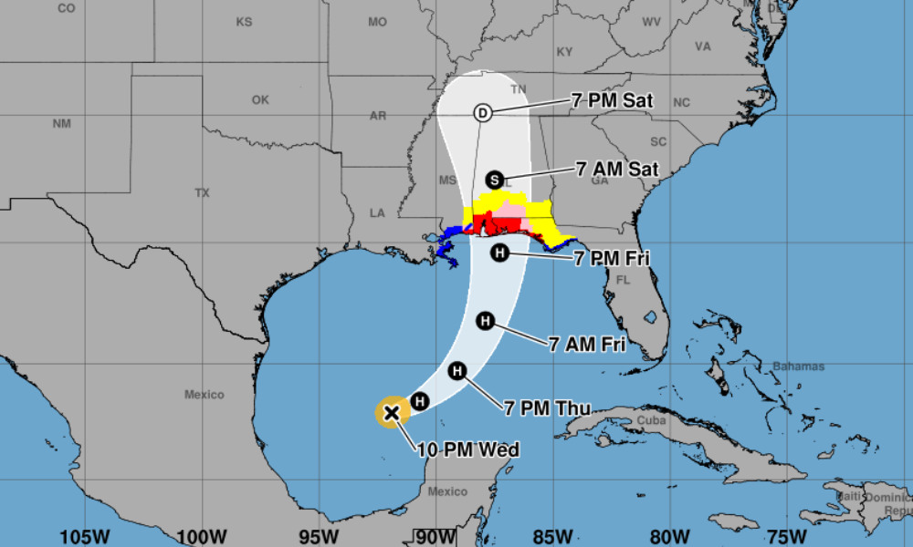
Hurricane warnings issued for Gulf Coast as Isaias strengthens
Hurricane and storm surge warnings have been issued for parts of the U.S. Gulf Coast as Tropical Storm Isaias nears hurricane strength, according to the National Hurricane Center (NHC). The storm is expected to make landfall late Friday night or early Saturday as a dangerous hurricane.
The hurricane warning, issued at 10 p.m. CDT on Wednesday, covers the coast from Ocean Springs, Mississippi, to the Bay/Gulf County line in Florida. Damaging hurricane-force winds are expected across portions of southern Mississippi, southern Alabama and the Florida Panhandle.
“Residents in these areas should prepare for the possibility of long-duration power outages,” the NHC said.
A storm surge warning extends from the mouth of the Mississippi River to the Steinhatchee River in Florida. The NHC said life-threatening coastal flooding is expected and residents should follow local officials’ instructions, including any evacuation orders.
A storm surge watch remains in effect from the Steinhatchee River to Yankeetown, Florida.
Tropical storm warnings cover the coast from the Jefferson/Plaquemines Parish line in Louisiana to just west of Ocean Springs, Mississippi, and from east of the Bay/Gulf County line to the Aucilla River in Florida. These warnings replaced the remaining portions of the earlier hurricane watch.
A hurricane warning means hurricane conditions are expected somewhere within the affected area. The NHC said preparations to protect life and property should be completed before tropical-storm-force winds make outdoor work difficult or dangerous.
Isaias had maximum sustained winds of 70 miles per hour and was about 460 miles south-southwest of the mouth of the Mississippi River. It was also about 180 miles northwest of Progreso, Mexico, moving east-northeast at 9 miles per hour.
Air Force Hurricane Hunters measured a central pressure of 988 millibars and reported a developing circular eyewall that remained open on its southwestern side.
The storm is forecast to accelerate northeastward on Thursday and turn northward on Friday. The latest forecast calls for maximum sustained winds to reach 110 miles per hour Friday morning before some weakening as Isaias approaches the coast.
“Rapid intensification is a distinct possibility,” the NHC said, citing very warm water and a moist environment. Increasing wind shear on Friday could limit the storm’s strength, but forecasters expect it to remain dangerous through landfall.
Gusty winds are expected well inland after landfall as the storm’s wind field expands. Heavy rainfall could cause flash and urban flooding, along with isolated river flooding, across the central Gulf Coast and much of the Southeast from Friday through the weekend.