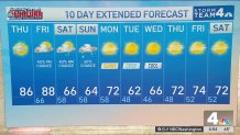
Storm Team4 Forecast: October starts off with a summerlike feel in mid-80s
4 things to know about the weather:
- Nice & warm Thursday, Friday
- Rain returns Friday PM
- Cool, showery weekend
- October chill next week
From making a run at 90° to the potential for frost, we’re going to be in an active weather pattern over the next five to six days.
The warm air comes first as most of the area will see highs reaching the low to mid-80s Thursday and upper 80s to 90° on Friday.
There are quite a few clouds around Thursday morning and they could deliver a sprinkle of rain in northern Maryland but the vast majority of the area won’t have to worry about rain until late Friday afternoon and evening.
For those of you who love warm weather, this is going to the last of it for at least the next 10-14 days. On average our last 80° of the year comes on Oct. 14 but we have hit 80° in the first week of November as recently as 2022 and 2024.
Needless to say, we’re quickly running out of time to hope for 80° days. A cold front will reach the area on Friday evening. Ahead of that front, Friday afternoon will be toasty warm. D.C. has about a 40% chance to reach 90° Friday. Odds are better for areas south of D.C. along the I-95 corridor.
Showers are likely Friday night into Saturday morning but rain totals won’t add up to much. Maybe 1/4 of an inch if you’re lucky.
Download the NBC Washington app on iOS and Android to check the weather radar on the go.
Rain chances for the weekend
As that front settles to our south, we will be let with a cool, cloudy and dry Saturday afternoon and evening. Highs Saturday afternoon will only be in the low to mid-60s.
The big wildcard for rain chances is the Sunday forecast. A wave of low pressure will develop along that same cold front to our south. How far north can that storm send rainfall is the big question.
The southern half of our area is far more likely to get rain (and a good bit of it) on Sunday than the northern half is. Sunday rain totals could range from 1/10 of an inch or less in northern Maryland to 3/4 of an inch or more for southern Maryland and the Fredericksburg.
A second, much stronger cold front will arrive Sunday night. This will bring an end to any rain chances and deliver our first shot of genuinely chilly fall weather. Sunny skies with highs in the low to mid-60s on Tuesday and Wednesday of next week.
There will be a frost/freeze concern for areas west of the Blue Ridge on Monday night and Tuesday night. Even the D.C. metro area could see temperatures fall as low as 40-45° those nights so start looking for your heavier coats.
NBC Washington
NBC Washington
QuickCast
THURSDAY:
Morning cloudiness
Sunny afternoon
Quite warm, humid
Wind: southwest 5-10 mph
Chance of rain: 10%
HIGHS: 82° to 87°
THURSDAY NIGHT:
Passing clouds
Remaining mild, dry
Areas of fog by morning
Wind: southwest 5 mph
Chance of rain: 0%
LOWS: 62° to 67°
FRIDAY:
Hot, humid for October
Increasing clouds
Isolated showers after 4pm
Wind: southwest 5-10 mph
Chance of rain: 40%
HIGHS: 86° to 92°
SATURDAY:
Mostly cloudy
Much cooler
Scattered AM showers
Wind: north/northeast 5-15 mph
Chance of rain: 40%
HIGHS: 62° to 67°
SUNDAY:
Cloudy and cool
Showers likely
Rainfall up to 1/2”
Wind: northeast 5-10 mph
Chance of rain: 60%
HIGHS: 58° to 64°
Sunrise: 7:04 Sunset: 6:51
Average High: 75° Average Low: 58°